The world is becoming more open for the Ukrainians. On the 17th of May 2017, citizens of Ukraine have been granted visa-free travel in the EU, as the European Parliament gave final approval in Strasbourg, France. This decision will come into force on the night of June 10th, 2017. From then, the Ukrainians will be able to enter all EU member states (excluding the UK and Ireland) and 4 of the associated Schengen States (Iceland, Liechtenstein, Norway and Switzerland). The main requirement is the availability of biometric passports. Besides, the Foreign Ministry of Ukraine comments that this decision opens the way for visa liberalization with about 30 countries of the so-called “white Schengen list”, which includes some states of Europe, North and South America, the Gulf of Persia and Asia. Discussions on visa-free travel for citizens of Ukraine with this group of countries have been going on since 2015.
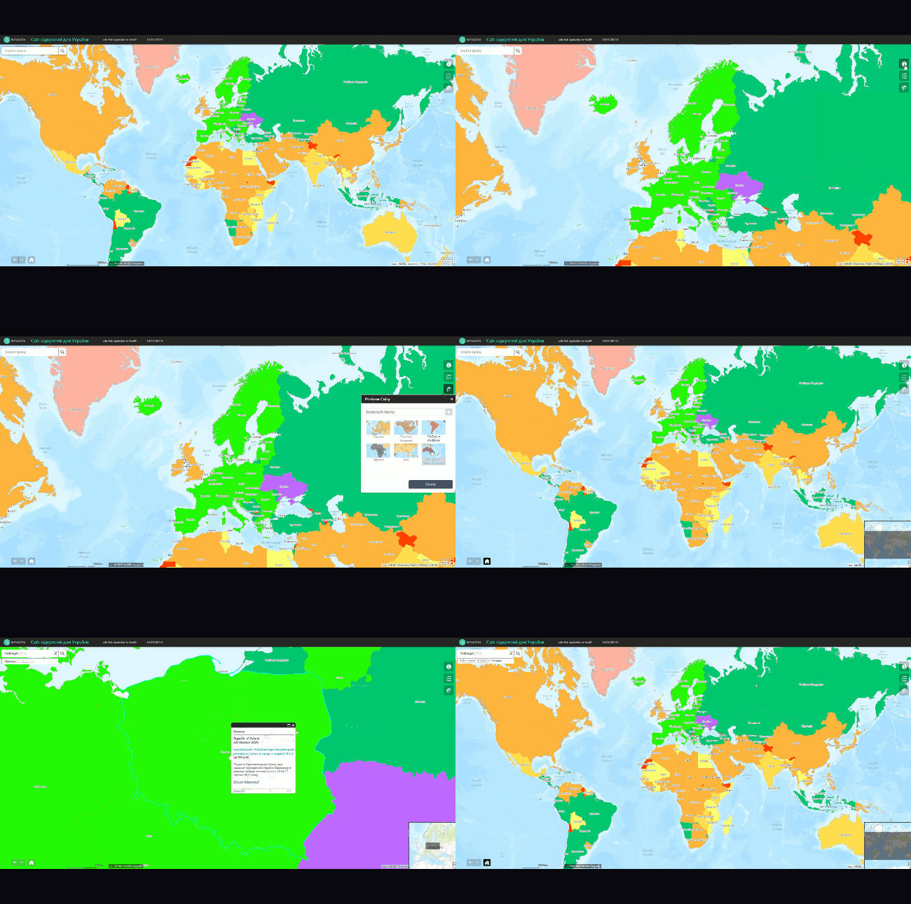
The European Union opens its doors to Ukraine. What about other countries? How open in the world for Ukraine today? These questions led me to create a web application with an interactive web map that would show the entry requirements for citizens of Ukraine to different countries of the world. As a result, I’ve developed a web application through WebApp Builder for ArcGIS (integrated into ArcGIS Online). You can explore the map itself below.
The information on the mode of entry into foreign countries for Ukrainian citizens is taken from the official site of the Ministry of Foreign Affairs. Vector base layers are from Natural Earth.
Web application functionality
The main component of the app is the web map, it consists of two web layers. The base layer represents the world countries, classified by mode of entry (visa /no visa), and entry specifics, concerning the requirements of obtaining a visa. An additional web layer is showing occupied and disputed territories (outside Ukraine). This information is important for planning trips as visiting these areas is associated not only with danger to life and health, but also can lead to the prohibition of entry into other countries. For example, a visit to the territory of Nagorno-Karabakh results in the automatic inclusion of foreigners in the list of persona non grata in Azerbaijan.
The map is interactive, when clicking on a specific country a pop-up message box with an info card appears.
The pop-up shows the following information:
- Header – country or territory name in Ukrainian.
- Full country or territory name in English, its status.
- Entry requirements.
- Permitted length of stay.
- Remarks on special conditions of a visit.
- Foreign Affairs Ministry link.
The functionality of the web application is implemented using widgets – map interaction tools that can be configured to user’s needs in WebApp Builder for ArcGIS.
The lower left corner contains map extent buttons (zoom in/out, “home” button that zooms to default extent). In addition, the scale and current coordinates are placed at the bottom. The lower right corner contains an overview map button. It helps when navigating the map.
In the top right corner, one can find widgets for additional information window, map legend and bookmarks. The information window has the additional explanation about visa-free entry to the EU and Schengen countries. For ease of map use the regions of the world are bookmarked (Europe, the Americas, Asia, Africa, Australia and New Zealand).
It is possible to search for a specific country by name in Ukrainian: the search bar is located in the top left corner. To find the country that interests you, just start typing in the search bar, the options will appear below. To go to the selected country click on its name in the drop-down list, the map extent will move to fit the country, and the info pop-up will open.


