Усе більше людей кожного року все частіше подорожують, і все менше з них користуються паперовими картами.
Ще 10 років тому, збираючись приїхати до незнайомого міста, було необхідно заздалегідь подивитись адресу офісу туристичної інформації, щоб взяти там карту. Сьогодні ж ми з легкістю знаходимо локацію з найсмачнішою піцою в чужому місті без будь-якого контакту з місцевими мешканцями.
Поступово системи глобального позиціонування стали невід’ємною частиною нашого життя, як соціального, так і особистого. Смартфон сам підпише ваше місцезнаходження під фотографією з вечірки, фейсбук підкаже, які з друзів наразі знаходяться недалеко від вас, а навігатор спланує найкраще транспортне сполучення, щоб доїхати звідси до Барселони.
GPS − наш порадник, помічник і товариш. Але − катастрофа! − системи глобального позиціонування фактично не працюють всередині будівель.
Чому GPS не працює всередині будівель?
Експерти з навігації пояснюють цю відмінність між сигналами GPS та мобільного телефону тим, що принцип роботи цих двох технологій базується на різних якостях хвиль. У випадку з телефоном для його нормальної роботи найголовніше − зміст сигналу, тож задля уникнення перебоїв в телефонній комунікації ми можемо ретранслювати його декілька разів.
На відміну від телекомунікацій для супутникової навігації має значення не зміст сигналу, а який саме шлях він пройшов від супутника до приймача. Тож, якщо спробуємо ретранслювати сигнал GPS, то втратимо саме ту частину, що потрібна для визначення нашого місцезнаходження.
Для чого потрібні системи внутрішнього позиціонування
Підприємства та компанії можуть користуватися системами внутрішнього позиціонування для організації виробництва та з потреб безпеки. Відстеження виробничих одиниць, менеджмент робочих місць, сервіси для відвідувачів та додатки для робітників − це все автоматизує та спрощує функціонування компанії. В залежності від потреб можна визначати розташування людини, рухомого об’єкта або кількість людей/об’єктів на визначеній території.
Для суспільних просторів системи внутрішнього позиціонування також можуть вирішити багато проблем. Швидка та зручна навігація всередині комплексних структур, таких як аеропорти, транспортні системи міста, університетські містечка, торгові центри та лікарні − це дуже логічне продовження інформатизації та технологізації нашої повсякденності.

Джерело зображення: wikimedia.org
У багатьох туристичних локаціях та музеях світу для туристів розроблено аудіоекскурсії, впродовж яких людина може гуляти, наприклад, всередині Бундестагу, тим часом як аудіогід буде, керуючись розташуванням відвідувача, пояснювати, що особливого знаходиться навкруги в даний момент або які видатні місця Берліну видно з найближчого вікна.
На рівні керівництва держав системи внутрішнього позиціонування вже розглядаються в якості ключової технології для вдосконалення систем реагування на надзвичайні ситуації.
Технології внутрішньої геолокації
Проблема сформульована: потрібно визначити точне розташування об’єкта всередині будівлі.
До того ж дуже бажано знати швидкість руху об’єкту, його орієнтацію в просторі та висоту.
Все ще не існує одного досконалого рішення, однак стартапи з різних куточків світу намагаються розробити оптимальний підхід для розв’язання цього питання.
Для потреб застосунків внутрішньої навігації Apple використовує бездротову технологію Bluetooth low-energy (BLE), Британський розробник Mulaboo базує свої розробки на комбінації BLE та WiFi. Деякі з компаній-розробників роблять ставку на радіосигнали ультраширокого діапазону, що можуть проходити через стіни будівель. На цьому варіанти технологій для визначення місцезнаходження об’єкта всередині будівель не закінчуються, і для всіх з них лімітуючими факторами є вартість та точність визначення. На сьогодні ж у цій сфері найшвидше набирає популярності WiFi-локалізація. За словами професора Електричного на Комп’ютерного Проектування Ворчестерського Політехнічного Інституту штату Масачуссетса Каве Палавана, прогрес не завжди відображає теперішні технічні можливості відповідної галузі науки. Доволі часто бізнес впливає на визнання або ігнорування конкретних технічних досягнень та відкриттів. “Фактично, важливим стає те, що обирає індустрія,” − каже Каве, − “Сьогодні, WiFi-локалізація є найбільш популярною.”
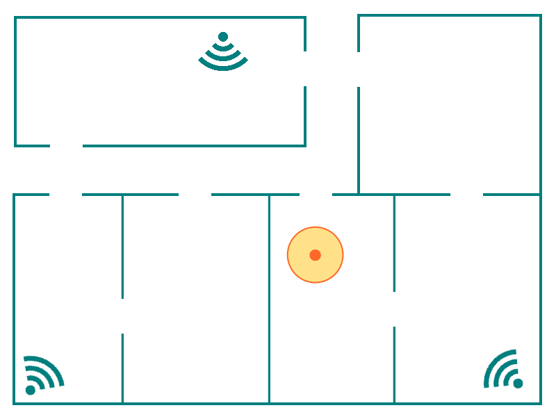
На теперішній день не існує єдиного стандарту для визначення внутрішньої геолокації. Часто виробники використовують не один сигнал, а комбінацію даних, що отримані від різних сенсорів смартфона: GPS, WiFi, дані вишок мобільного зв’язку та інші.
Окрім відсутності стандартів у сфері, існує ще два фактори, що уповільнюють розвиток та поширення систем внутрішнього позиціонування: точність визначення місцезнаходження об’єкту, а також потреба у картографуванні внутрішніх просторів будівель.
Існують різні підходи до розв’язання цих задач, і тому сьогодні можна знайти дуже різні за концепцією та технічною реалізацією платформи для внутрішньої навігації.
Цікаво, що проблему визначення точного розташування деякі виробники програмного забезпечення вирішили за допомогою використання інструментів доповненої реальності, тоді користувач може орієнтуватися за візуальними підказками навколишнього світу, доповненого планом приміщення на екрані телефону. Таким чином, спрощується і процес навігації для користувача, і дещо спрощується технічна сторона створення додатку для розробників (хоча для колег з геодезичною освітою це може виглядати шокуючим − бо точність таких додатків зводиться до знаходження людини в цій чи іншій кімнаті).
Питання внутрішньої картографії, так само, має декілька варіантів відповіді. Не дивно, що Google та Apple інвестують багато ресурсів і в розвиток технології, і в розширення бази об’єктів з доступною внутрішньою навігацією. Проте, жодна з компаній-гігантів не має повнофункціонального картографічного продукту для внутрішньої навігації, на який можна розраховувати, наприклад, під час швидких пересадок в аеропортах.
Більше того, комерційні структури створюють додатки внутрішньої навігації за власний кошт, і самі ж ними користуються. А музеї та університети вже створюють системи навігації для покращення досвіду відвідування своїх закладів, які є відкритими для всіх бажаючих.
Нижче наведено декілька прикладів систем внутрішньої навігації. Сподіваємось, вам щось із цього списку буде цікавим і знадобиться в майбутньому. Або ж надихне на розробку власної системи внутрішньої геолокації.
Приклади: платформи та додатки
Віденський Економічний Університет
Джерело зображення: gis.wu.ac.at
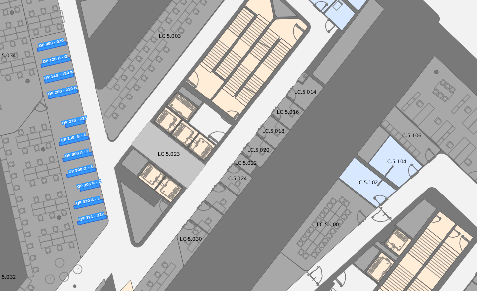
Навігаційний додаток для кампусу Віденського Економічного Університету представляє собою комбінацію глобальної та внутрішньої систем позиціонування. Додаток дозволяє обчислити маршрут за назвою корпусу, аудиторії, категорією POI, а також при плануванні маршруту можна вибрати опцію прокладання безбар’єрного маршруту для людей з особливими потребами. Можна роздрукувати вибраний фрагмент плану, змінити режим відображення з 2D на 3D і навіть знайти, на якій кафедрі, або в якому корпусі бібліотеки знаходиться необхідна вам книжка, – і всі ці можливості доступні просто через поле запиту.
Джерело зображення: meridianapps.com
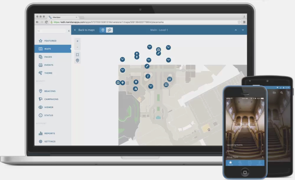
Meridian − це одночасно і платформа для створення додатків для внутрішньої навігації, і база локацій з доступною внутрішньою навігацією. За допомогою вже розроблених навігаторів у Meridian можна відчути себе місцевим у Китайських Садах Лан Су або пройти екскурсію в Нью-Йоркському метро, де знаходиться відкрита галерея мистецтва, що складається з різноманітних робіт художників.
Мабуть, найвідомішим додатком, розробленим на платформі Meridian, є AMNH Explorer для Американського Музею Природознавства. Цей додаток не тільки допомагає орієнтуватися у просторі та має вичерпну інформацію про експонати, а й зберігає історію персональних музейних досліджень відвідувача.
Here, Venue Maps

Here Maps об’єднали простір всередині та зовні будинків − просто і корисно. У цих картах можна наблизити будівлю, і якщо її внутрішній простір закартографований − то можна просто перейти на режим внутрішньої навігації. Компанія намагається мислити глобально, тож наразі доступна внутрішня навігація для більш ніж 50,000 локацій у 45 країнах світу.
І якщо ви перший раз, наприклад, у Харкові, і не маєте уявлення, в якій частині торговельного центру “Караван” можна купити посуд, то тепер ви знаєте, де шукати підказку!

Джерело зображення: wikimedia.org
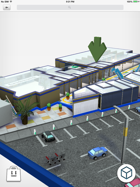
Можливо, це найкраще рішення для навігації у величезних шопінг-центрах. В додаток Mally входять і 3D карти простору, і можливість 360° перегляду, і можливість включати до свого маршруту магазини, місця або події.
Єдиний нюанс − невелика кількість торгових центрів, що мають покриття Mally. Більшість з яких знаходиться в Іспанії.
Якщо Mally пошириться на всі багатоповерхові шопінг-центри, у них є всі шанси перетворити походи за покупками на щось більш приємне.
Як ми бачимо, у сфері систем внутрішнього позиціонування вже зроблено багато відкриттів, проривів і застосунків. Над деякими аспектами інженерам та розробникам ще треба працювати, але вже існує достатньо продуктів, якими можна користуватися, також існують можливості для створення власних продуктів на готових платформах.
Тож час навігації в лабіринтах будованих структур настав.
Якщо у вас є досвід використання систем внутрішньої навігації, нам буде цікаво почути про це в коментарях.



We spend most of our lives indoors, yet the GPS services that serve us so well outdoors are blind when they can’t see the sky. Leaps in indoor positioning system accuracy provided by a large number of competing technologies, along with the already booming availability of indoor maps, point to a new frontier of indoor location-based services. Thank you for sharing this blog. You can visit Ubitrack at https://www.ubitrack.com/ for best positioning devices.
Проблемою мапінгу в середені приміщень учасники ОСМ почали займатись ще до того, як Google представив власні напрацювання на розгляд широкого загалу. Щоб отримати більш докладну інформацію ознайомтесь з порталом у Вікі-ОСМ http://wiki.openstreetmap.org/wiki/Indoor_Mapping.
Однією з перших спроб додати план приміщення був торговельний центр Jazz у Северодонецьку – http://www.openstreetmap.org/?lat=48.944006&lon=38.493187&zoom=18&layers=M
Крім того можна ознайомитись з варіантами використання даних ОСМ для створення мап примищень – http://wiki.openstreetmap.org/wiki/Indoor_Mapping#active_indoor_maps
Якщо у вас є потреба в створені такої мапи – ви вже зараз можете розпочати роботу над нею приєднавшись до спільноти ОСМ