За даними ООН понад 54 % населення Землі проживає в містах. Звісно, саме поняття «місто» відрізняється залежно від континенту та країни. Але незалежно від розташування усіх жителів міст об’єднує бажання жити в безпечному, комфортному та привабливому середовищі. За формування цього середовища рівною мірою відповідають як місцева влада, так і громадськість. Та для забезпечення якісних змін міського середовища, їм потрібне розуміння яким місто є зараз, як взаємодіють між собою муніципальні служби, наскільки доступним є місто для пересування людей, які його території першочергово потребують змін. Перелік цих питань можна продовжувати безкінечно, і відповідь на кожне з них різнитиметься для кожного міста. Єдине, у чому можна бути впевненим, що вся інформація необхідна для їх отримання, матиме певний просторовий контекст, а тому найкращим інструментом для її опрацювання стане ГІС. Тому давайте розберемося, що таке ГІС міста, хто її користувач, які дані вона повинна включати та на основі яких технологій будуватися.
Чим є ГІС міста?
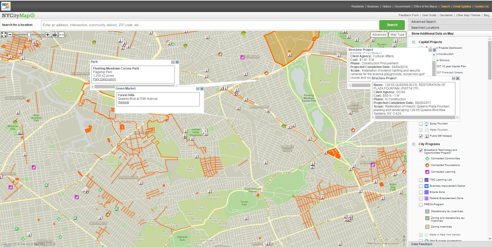
Чітке визначення ГІС міста (або муніципальної ГІС) сформулювати достатньо складно. В україномовному сегменті Вікі є визначення: «Муніципáльна ГІС (МГІС) — комплекс методологічних, організаційних, програмних, технічних і інформаційних засобів, покликаних підвищити ефективність управління інфраструктурою міста на основі застосування новітніх інформаційних технологій». Але, якщо врахувати, що будь-яка ГІС певної території — це «комплекс методологічних, організаційних, програмних, технічних і інформаційних засобів» які базуються на основі IT-технологій, то це визначення можна спростити до: «Муніципальна ГІС — це ГІС, що підвищує ефективність управління інфраструктурою міста». Та якщо запитати в Гугла щось на зразок «city GIS» то виявиться, що можливості реальних ГІС міста є значно ширшими. Наприклад, ГІС міста Нью-Йорк надає інформацію про об’єкти, що будуються та знаходяться на реконструкції, відкриті Wi-Fi точки, програми розвитку міста та десятки інших інформаційних складових, які є цікавими насамперед для громадян міста, а не його керівництва.
ГІС Нью-Йорку
Подібна картина спостерігається і для низки інших міських ГІС, у яких інформаційно-довідкова функціональність переважає управлінську. Такий підхід є цілком логічним, зважаючи на те, що маючи доступ до різноманітної інформації, значно простіше приймати управлінські рішення, але хто сказав, що ця інформація не може виявитися корисною і для пересічних мешканців міста?
Загалом, розглянувши ГІС декількох десятків міст, можна стверджувати, що для міських ГІС визначальними є такі особливості:
охоплення території міста та інколи передмість;
акцентування уваги на інформації, необхідній для жителів міста;
фінансування за рахунок міського бюджету.
Чим не є ГІС міста?
На питання «Чим є ГІС міста?» відповісти достатньо складно й можна довго дискутувати, якими саме якостями вона повинна володіти. Але, як це часто буває, набагато важливіше визначитися, чим не є ГІС міста, щоби не виявилось, що кошти міського бюджету витрачені на створення сервісу, який або нікому не потрібний, або буде конкурувати за функціональністю та інформаційним наповненням з Google Maps чи OpenStreetMap. Отже:
ГІС міста — це не містобудівна стратегія.
Читаючи описи функціональних можливостей сучасних ГІС-платформ для побудови муніципальних ГІС, формується враження, що впровадження такої ГІС одразу вирішить усі проблеми міста. Так, керівництву міста достатньо буде сидіти перед монітором і віддавати накази муніципальним службам, спостерігаючи за їх виконанням у режимі реального часу. Реальність, звісно, набагато прозаїчніша, й навіть такі міста, як Амстердам, Барселона або Стокгольм, що вже роками впроваджуть концепцію «розумного міста», досягли успіхів в автоматизації лише окремих аспектів життєдіяльності міста (наприклад, моніторинг вільних місць для паркування в Амстердамі або забезпечення «зелених коридорів» для громадського транспорту в Барселоні).

Це не ГІС міста
ГІС міста — це не ГІС для комунальних служб.
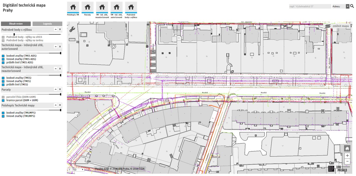
Шари з інформацією про розташування підземних і надземних комунікацій міста, безумовно, є надзвичайно важливими для ГІС міста. Але якісну розробку цих даних можуть забезпечити тільки відповідні комунальні служби, а тому логічним є те, що міська ГІС повинна тільки агрегувати в собі інформацію з комунальних баз геоданих та надавати можливість їхнього спільного використання. Але створенням просторових даних повинні займатися всі комунальні служби в рамках своїх власних ГІС. Такий підхід, з одного боку, дозволить підвищити ефективність збору та управління даними, а з іншого дозволить під час розробки муніципальної ГІС сконцентруватися на аспектах взаємодії та обміну просторовими даними, а не рутинних процедурах їх збору. У якості прикладу можна навести ГІС Праги, де інформація про систему комунікацій міста винесена у вигляді окремого сервісу доступного як для комунальних служб, так і для всіх городян.
ГІС технічної інфраструктури Праги
ГІС міста — це не рекламний сервіс.
Починаючи розробку муніципальної ГІС, у міської влади одразу з’явиться цілком природнє бажання зробити її самоокупною. І найпростішим рішенням для досягення цього є початок співпраці з рекламодавцями. Але в такому випадку міській ГІС доведеться конкурувати з цілою низкою комерційних проектів, а згодом різниця між ГІС міста й пересічним рекламним геопорталом може стати взагалі розмитою. Тому в переважній більшості муніципальних ГІС інформацію рекламного харакетеру можна побачити тільки як частину базової карти Google або вона спрямована на просування сервісів міста (наприклад, ринків із фермерською продукцією).
Хто користувач міської ГІС?
Як уже згадувалося раніше, інформація, що міститься в ГІС міста необхідна як для його керівництва, так і для кожного мешканця. Це твердження можна підтвердити сотнями прикладів ГІС міст США, Канади, ЄС та навіть Індії. На жаль, в Україні воно не набуло значної популярності, та навіть в оглядово-аналітичних статтях про ГІС міста автори описують їх виключно як інструмент для міських посадовців, який може використовуватися тільки для прийняття управлінських рішень. Такий підхід є не оптимальним із декількох позицій.
ГІС міста розробляється за кошти міського бюджету, і відповідно кожен із мешканців міста має право на її використання. У чому проявлятиметься це використання вже залежить від конкретного жителя. Хтось може використовувати її як звичайну веб-карту, а хтось як інструмент для громадського контролю або впровадження місцевих ініціатив із розвитку міста. Але сама інформація повинна бути доступною для мешканців, а міська влада зобов’язана надати зручний інтерфейс для її використання.
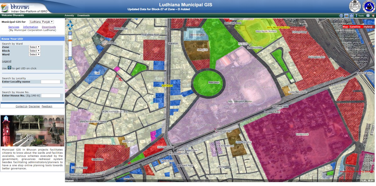
ГІС міста Лудхіяна
Давно минули ті часи, коли для роботи з просторовими даними потрібно було встановлювати потужну настільну ГІС типу ArcGIS чи MapInfo. Можливості технологій сучасних геопорталів дозволяють виконувати переважну більшість операцій із перегляду, маніпулювання та навіть базового просторового аналізу, не виходячи з вікна браузера. З огляду на це, бачимо, що муніципальна ГІС повинна розроблятися саме у форматі геопорталу, доступ до якого легко організувати для всіх мешканців міста. До того ж, формат геопорталу зручніший навіть для міських посадовців, яким не доведеться опановувати роботу в настільній ГІС, а достатньо навчитися працювати зі «ще одним сайтом».
Розвиток IT-технологій призвів до того, що потужні інструменти з обробки та аналізу даних доступні кожному. І зовсім неочевидно, хто краще зуміє сформулювати стратегію розвитку міста, шляхи підвищення рівня його комфортності або оптимальну схему маршрутів громадського транспорту. Так, може виявитися, що група ентузіастів із фейсбуку, озброєна R, Wolfram|Alpha та QGIS, запропонує значно ефективніші рішення, ніж відділ міської ради з багаторічним досвідом та професійною освітою. Але і першим, і другим для прийняття зважених рішень потрібні дані, для чого, власне, і створюється ГІС міста.
Яким має бути інформаційне забезпечення ГІС міста?
Інформаційне забезпечення муніципальних ГІС достатньо сильно різниться між собою. Але є певні загальні тенденції, які відрізняють муніципальні ГІС США та Канади від ГІС європейських міст. Так, якщо взяти ГІС пересічного американського міста, інформація представлена в ній, охоплюватиме практично всі аспекти життєдіяльності міста, починаючи від шару з кадастровим поділом і завершуючи шаром із розташуванням пожежних станціій. Водночас для ГІС європейських міст часто характерним є скромніше інформаційне наповнення, яке стосується виключно специфічних даних (наприклад, підземних комунікацій). Проте, для європейських країн характерною є розробка національних геопорталів, що містять надзвичайно великі обсяги різноманітних прострових даних, сформованих відповідно до директиви INSPIRE. У якості прикладу можна навести національний геопортал Польщі, який за інформаційним наповненням фактично об’єднує в собі ГІС усіх міст країни.
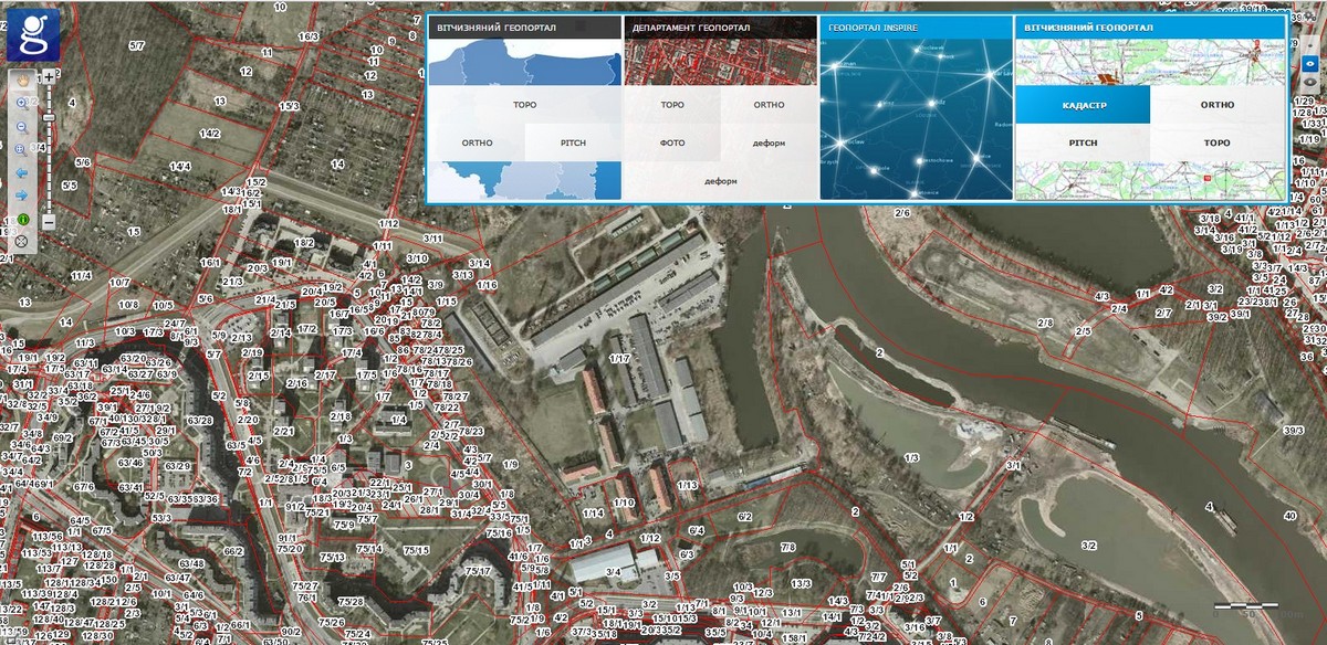
Національний геопортал Польщі
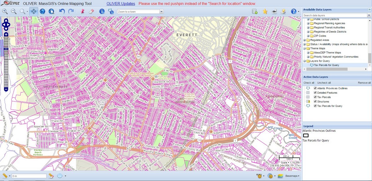
Інформаційне забезпечення ГІС міста також нерозривно пов’язане з поняттям відкритих даних. Бо недостатньо опублікувати інформацію в середовищі ГІС та забезпечити можливість візуального ознайомлення з нею. Цього, звісно, вистачить для переважної частини мешканців міста, але є недостатнім для активних громадян, що на основі даних ГІС забажають створювати нові сервіси, карти чи аналітичні доповіді. Тому, враховуючи загальну важливість забезпечення даними для розвитку громадянського суспільства, ГІС міст повинні надавати можливості доступу до представленої в них інформації в певних стандартних форматах (наприклад, *csv або *shp). Як приклад, можна навести ГІС штату Массачусетст, що охоплюючи понад 350 населених пунктів, дозволяє завантажити практично кожну складову карти у форматах (*xls, *csv, *shp або *kml).
ГІС штату Массачусетст
Які технології використовуються для побудови міських ГІС?
Подібно до інформаційного забезпечення, технології побудови ГІС різних міст досить суттєво різняться. Значна частина міст США надають первагу використанню можливостей геопорталів від компанії ESRI. Технологічний рівень цих геопорталів може варіюватися від звичайної веб-карти на базі ArcGIS Online до потужних рішень, що включають десятки інтерактивних карт різної тематики (наприклад, ресурс BostonMaps). Міста Європи дещо менше використовують технології ESRI для побудови своїх ГІС, надаючи перевагу або повністю власним розробкам, або використовуючи технології MapServer, OpenLayers та їхні комерційні аналоги. На жаль, розглядаючи ГІС різних міст, мені так і не вдалося знайти жодну ГІС міста, побудовану на основі виключно відкритих ГІС (сподіваюсь, хтось із читачів зможе виправити це в коментарях).
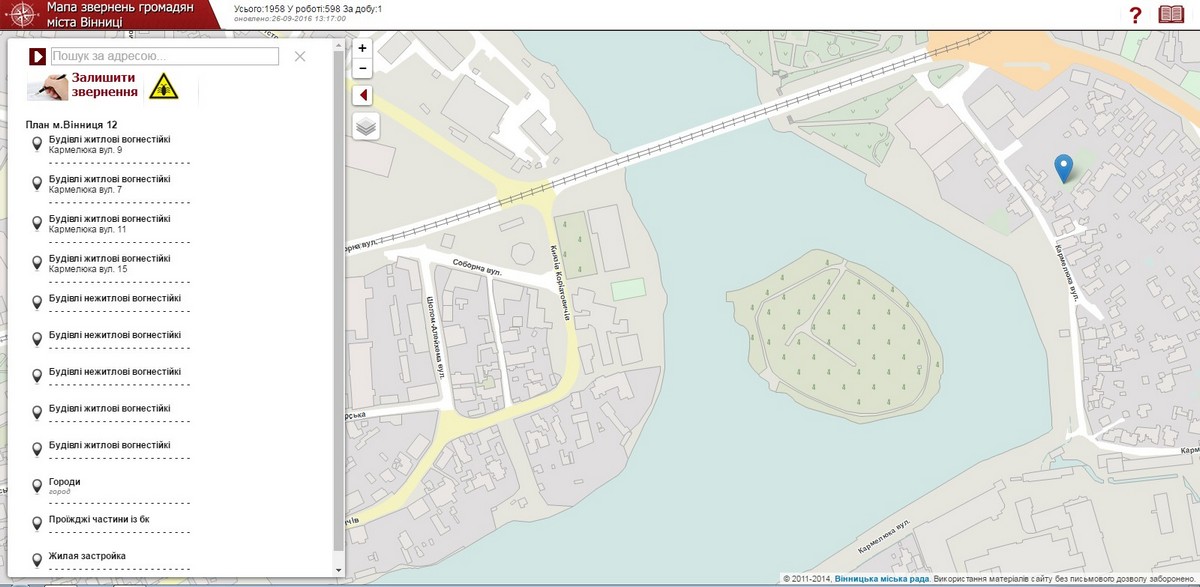
Щодо ГІС міст України, то їхні розробники переважно орієнтуються на комерційні продукти. Але враховуючи незначну кількість муніципальних ГІС міст у нашій країні, що знаходяться у відкритому доступі, складно робити чіткі висновки, щодо того яким технологіям надають перевагу вітчизняні розробники таких ГІС. Наприклад, згідно з даними офіційних сайтів, міський інформаційний центр Харкова використовує продукти компанії ESRI, а Вінницька міська рада віддає перевагу продукції КБ Панорама. Про ГІС міста Вінниця також варто згадати з огляду на те, що це єдина відома автору функціонуюча ГІС міста України, яка знаходиться у відкритому доступі та надає багато різноманітної інформації про місто (шкода, тільки, що розробники не додали посилання на бібліотеку Leaflet.js, яку вони активно використали під час розробки геопорталу).
ГІС Вінниці
Про ГІС і місто можна говорити й писати довго. І з кожним роком ця тема однозначно ставатиме популярнішою, беручи до уваги ті зміни, які зараз спостерігаються в українських містах. Але важливо не тільки розмірковувати про певну «ідеальну ГІС», яку можна побудувати, маючи необмежені фінансові та часові ресурси, а починати робити конкретні невеликі кроки з розробки, хай і недосконалих, але працюючих ГІС. Участь у цьому процесі може приймати як місцева влада, так і державні органи (згадаймо про карту сміттєзвалищ України) та прості громадяни (наприклад, у рамках проекту OpenStreetMap чи інших краудсорсинових проектів), у сукупності отримуючи спільну вигоду.





м. Києв
http://gis.kievcity.gov.ua/
м. Львів
https://map.city-adm.lviv.ua/
Hi Yaroslav,
Excellent article.Thanks for sharing.
http://www.vayamtech.com