Planet Explorer is a web browser interface used to search and view imagery from the archive of Planet Labs. This web application provides access to daily satellite imagery for customers, researchers and the general public.
Data access
At the moment, there is an option to subscribe to a free two-week trial, after which you need to pay for a commercial subscription, but there is no accessible data on the terms of such a subscription. Registration provides access to Planet Explorer Beta, Mosaic Explorer, and a personal API key.
A trial subscription gives you access to data through Planet Explorer. Data usage may not be commercial. After registration, the user can view and download the Planet data and has access to monthly mosaics as well as daily images of Sentinel, Landsat, RapidEye.
Open California dataset
The Open California (CC BY-SA license) provides access to California archival data that is published two weeks after filming. That is, they can be used without a paid subscription.
Education and Research Program
Planet offers the ability to use their data for scientific purposes. There are three plans: Basic, Investigator, Institutional. Only the first basic subscription is free.
Students, researchers, and staff at accredited universities can access the data. Non-profit and civil servants do not have such a right. To obtain access, you need to fill out a form with a short description of your work.
Researchers can use the global data PlanetScope, Sentinel-2 and Landsat 8 with unlimited zoom. The RapidEye set is not available to users in Ukraine.
Up to 2GB of global data can be downloaded per day.
You can apply for the program here.
Interface and functionality
The interface is minimalistic and seems easy to use after several attempts to work with it. In addition, there is a virtual tour and hints that tell about the parts of the browser and their functions.
From first glance
The explorer window displays a mosaic of images. The top right corner contains a search box, on the right, there is a link to user options. At the bottom of the screen, there is a timeline, the bottom right corner contains a toolbox that lets you draw AOI (area of interest), download AOI borders in different formats, data coverage view options, zoom buttons and a scale bar.
AOI
AOI delineated the image search area. AOI creation tools allow you to draw rectangles, circles, and polygons on a map.
![]()
Timeline
Timeline allows you to select imagery by acquisition time. It is possible to choose daily images and monthly and quarterly mosaics.

Search options
Search can be done by geographic names, coordinates. You can also save the search parameters to return to your AOI later. Saved searches are stored in the user panel.

The search bar contains a tiny map showing the location of the middle of your screen.
When the time period and area are selected, the results appear under the search box. They show scenes that intersect with AOI geometry or screen extents.
Depending on the settings in the Timeline panel, different search capabilities are displayed.
For daily searches, there are metadata filters (cloud cover info, sampling distance, coverage of images of the area of interest, the selection of data sources, the sun azimuth, the off-nadir angle and spatial resolution).
There are no filtering options for image mosaics.

In order to be able to search for daily images, you must specify the search area (AOI), otherwise, the option is not active.
At the bottom of the search results panel, there are API buttons, link to ordering items (the number of selected scenes in brackets).

Image comparison
You can select scenes from search results for visual comparison. To do this, you need to press the Compare button, the screen will be divided into two parts, the selected images in each of them, and a slider in the middle.

Pixel diffing
Another option to compare images is to search for differences in relative brightness. Pixel diffing is an experimental feature that is included in Planet Explorer. You need to enable it in the user panel:
After switching the feature on, the Diff button will appear in the lower right corner when comparing the images. You can switch between views by using the Diff and Slide buttons.

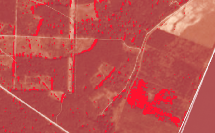
The difference in the brightness of the two compared images is highlighted in red. There is also a sensitivity slider setting.
It’s not clear how the Pixel diffing mechanism works. Most often, shifted or cloudy pixels are marked as changed, as well the seams between scenes. With very sensitive settings, the whole image can be viewed in red. The function only compares the visible range, as only such images are available for viewing in the explorer, and does not take into account the infrared channel.
We conveyed and experiment and chose a location of a forest fire for our AOI.
Two images were downloaded with Planet Explorer, image dates – August 20th and 27th, 2017, location – the outskirts of the village of Omelchenko, Kharkiv region, where a fire occurred on August 21st.
With the help of QGIS, a NIR-R-G composite was created, in which we see that there is a difference between the brightness of the images. Vegetation on such a composite looks red because the infrared spectrum has a high reflectivity. Therefore, the dark green spot that appears on the picture of August 27th is the area where the vegetation had disappeared (as a result of a fire).
 20/08
20/08 27/08
27/08
Using Planet Explorer we can look at the RGB-composite only. By comparing the images from the same dates online, you can notice a very small change in brightness.

However, the Pixel diffing tool with default sensitivity setting does not find the difference between the images. Only when the threshold slider is at a maximum, we see a red highlight around the location of the remains of the fire (as well as the probable location of shadows on the boundaries of the forest).

Let’s try the comparison on another example. If you use an example of an agricultural area, then the tool yields better results. Most likely, because the surface is more homogeneous, there are no shadows. But still, with the maximum Pixel diffing sensitivity threshold, it does not reflect all the differences that can be seen (for example, the fields in the centre in the image below). That is, even looking at the pictures, you can get conclusions without using additional tools. However, of course, the tool simplifies the process and displays what you need to pay attention to first.
Pixel diffing seems to require further work to make the comparison more qualitative and better than the visual comparison of the human eye.

Stories
The Stories option is available in Planet Explorer. In a special menu item, you can create your own timelapse with the selected area and time interval, and publish it.
User panel

The user panel contains four tabs: Searches, Orders, Labs and Settings.
Saved search parameters are displayed in Searches, and can be sorted into folders. Your download orders are displayed in Orders. After the initial order, it takes some time for the datasets to become available for download (status “In progress”). When the dataset is ready, a Download link appears next to the order name, and an email is sent to the user about it. The Labs tab contains test functions, and currently only has a Pixel diffing option. Settings tab stores the coordinate system and measurement settings

Among other custom settings (access to them in a separate window), select the language of the Explorer. There is a possibility of the Russian-language interface, but so far the explorer itself, its functions and the command are not localized.
In the settings, you can see download statistics for the selected period and download limits.
Conclusion
Planet Explorer Beta is a handy tool for finding, viewing and downloading images from Planet. This web application has a convenient and pleasant interface. In addition to the main purpose of accessing data, there are several tools for comparing images. However, these tools are still in need of further development to offer satisfactory results.


